THIS MUCH-INITIALLED gritstone boulder sits on top of the Cow at the Cow and Calf Rocks above Ilkley. To get this view I had to perch on another boulder, which wasn’t comfortable enough to encourage me to sit and draw it there and then so I took a photograph and today I’ve been working from that.
When I’m working from photographs I tend to get hooked into drawing every detail. In the real world the level of detail is so overwhelming that a natural editing process inevitably kicks in, enabling me to take more liberties with a scene and to be less literal than I am with the photograph.
A simple solution would have been to include exactly the same amount of detail but to draw the background with a finer pen which might have given more of an impression of aerial perspective. To a certain extent I thickened up the lines around the boulder by reworking them but I didn’t want to overdo that.
Hopefully when I add the watercolour there’ll be more depth in the illustration.
MUCH OF the bedrock that I’ve seen in rocks on the shore or in roadside cuttings is like this; it’s full of fragments of limestone, strongly bound in a cement of pulverised and powdered rock.
The 1 to 2 millimetre deep indentations on this pebble (right) are in rows too regular, I think, to be part of any geological erosion process. But I can’t imagine why any marine creature would go to the trouble of pitting out patterns in this way so my guess is that it is some kind of a fossil.
I’m not sure what species this large thistle was but it looked different to our Spear and Creeping Thistles.
Kumquat
The Kumquat was introduced to Corfu by an English botanist called Merlin. The fruits are turned into marmalade and also distilled to make a fruity liqueur. A Merlin variety of orange is still grown on the island.
This Spotted Flycatcher was perching on aerial, veranda and wire, darting off and hovering below the balcony of an empty villa.
This White Wagtail is the same species as our British Pied Wagtail but a different race. The continental male has a grey back, as shown in my sketch, while our Pied has a black back. The continental variety is Moticilla abla alba and the British race Moticilla abla yarellii.
Fragment of a Lakeland rock (I'm not sure exactly where I picked this up now!)
I REMEMBER this rock near the lakeside at Bowness from a childhood holiday in the Lake District. It’s been smoothed and polished not only by passing glaciers but also by the effect of several decades of children sliding down it. I remember joining a queue at the top and enjoying the slide down onto the turf below so much that I went back up and queued for a second go. I have a vague memory that there were two routes down; a nursery slope and an extreme sports alternative. It seemed a wild ride after the children’s slides that I’d been used to in council recreation grounds.
Close up of the fragment, approx. 10x, showing a mineral vein, probably quartz.
Unfortunately since the 1960s, the rock has been cut through to widen the road. It’s a shame not only for the children but also because this was such a prominent example of a roche moutonnée. I always thought this meant a sheep-shaped rock, smoothed by glaciers but, according to Wikipedia, when Alpinist Horace-Bénédict de Saussure came up with the term in 1786, he was thinking of the wigs, slicked down with mutton fat, which were worn by the nobility of the day.
In my memory, this ice-smoothed rock was further up the slope from the lakeside, far enough inside the park for a soft landing on the turf below. The road and the lakeside have been re-engineered here, so that might partly account for it but apparently the lake shore itself has changed. In Eric Hardy’sThe Naturalist in Lakeland, written in 1973, I was surprised to find a brief reference to an increase in the water level of Windermere, brought about by controlling the outlet at Newby Bridge, the aim being to provide a more reliable water supply for Manchester. This would have been in the 1960s.
And he refers to the time ‘when Morecambe Bay is converted to a barrage or to storage reservoirs’, as if the matter had already been decided.
The ‘Greywackes’ of Windermere
Slaty cleavage in a fragment of rock from the edge of the car park at the Belsfield Hotel.
Jonathan Otley(1766-1856), ‘the Father of Lakeland Geology’ observed that,
” . . . the greater part of the central region of the Lake Mountains is occupied by three distinct groups of stratified rocks of a slatey texture – the Clayslate, Greenstone and Greywacke.”
Otley’s ‘Clayslates’ are what we used to call the Skiddaw Slates, which underlie the smooth bulk of the fells of the north Lake District; the ‘Greenstones’ are the Borrowdale Volcanics of the knobblier central fells and ‘Greywackes’ are the Silurian rocks of South Lakeland, now known as the Windermere Supergroup.
In Lakeland Rocks, An Introductory Guide, Alan Smith describes the Windermere formations as ‘Geologically interesting but not charismatic for the non-specialist in any way.”
Link;Rigg Side Publications also publish Alan Smith’s The Story of the Bowder Stone, The Ice Age in the Lake District and, one that appeals to me as ideal to take on a future break in the Lake District, Landscapes around Keswick; it would be great way to get to know more about the landscapes Keswick, Bassenthwaite, Derwentwater and Borrowdale.
I DREW this group of tree ferns from plants in the fern house at Kew Gardens. It was a frosty winter weekend and the prospect of drawing in the shelter of a glasshouse appealed to me. Unfortunately when I got there the fern houses were closed for maintenance, so I had to stand on the frozen turf outside and draw this tropical scene through the window.
This was back in the winter of 1976-77 and I was gathering visual reference for my first book, A Sketchbook of the Natural History of the Country Round Wakefield, for a fold-out diorama of the coal forests which covered much of Britain 300 million years ago. The giant club-mosses and giant horsetails are long gone but modern tree ferns are almost identical in appearance to the tree ferns and ‘seed ferns’ (an unrelated but very similar looking group of plants) that grew in these primeval forests.
I felt that drawing from real plants would give a touch of believability to the drawing, a kind of ‘everyday’ look which can be difficult to achieve when you’re reconstructing an exotic landscape.
Today, I’ve been revisiting that landscape, part of my past as well as part of the distant past of our planet, as I’ve been asked to prepare a coloured version (coloured in Photoshop that is) for an information board for a country park on the site of a former colliery. The stored energy in the coal comes from sunlight that fell on these long vanished forests 300 million years ago.
22°C, 5.50 pm. THESE PIECES of sandstone at the corner of the pond provide access to the water for birds and perhaps some cover for newts and frogs. They also help disguise the edge of the black plastic pond-liner. The first pond that we dug when we moved here was lined with builder’s damp-proofing plastic – blue polythene sheeting – which wasn’t resistant to ultra-violet light. I covered the edges with turves and spread garden netting across the bottom of the pond and pressed sub-soil from the hole we’d dug into it. This produced a more natural-looking pond than our present one but it had a tendency to wick water away and the netting wasn’t a good idea; on one occasion I saw a frog that had been drowned when it had gone down into the mud and got caught in it.
Brachiopods
I noticed these impressions of fossils shells in the rock on the far right (top). Superficially they look like cockle-shells but these fossil creatures weren’t bivalve molluscs; the Brachiopods (the name is from the Greek meaning ‘arm-foot’) appeared in the Cambrian explosion of life on Earth and have been around for 570 million years. Three thousand fossil species have been described but today only about 100 living species remain. They have suffered from competition with bivalves such as cockles, oysters and mussels.
Modelling clay cast of brachiopod. I can't decide whether this is a complete shell or whether these are two valves from separate individuals which just happen to have fossilised together.
These fossils are negative impressions of the shells so I pushed a piece of modelling clay into the hole and made this positive cast of the original shell. When this shell was last visible on the surface of the earth it was on the seabed at a time when our part of the Earth’s crust lay close to the equator, some 300 million years ago in the Upper Carboniferous period. As the fossil is in sandstone, I guess these brachiopods must have been living near the mouth of a river.
The ribs on the shell bear this out as they indicate that this species of brachopod was adapted to live in shallow water in a strong current. A smooth shells would indicate a species that lives in deeper, calmer waters. That zig-zag line which marks the opening of the shell is known as the commisure (below right); brachiopods developed a folded commisure to increase feeding area while preventing sand particles entering.
Brachiopods stood on a pedicle stalk anchored on the seabed and opened and closed the two valves of their shells to feed. The hole in the shell where the stalk protruded led to them being given the name ‘lamp-shells’, as the larger valve resembles a Roman oil-lamp, with a hole for the wick.
THE DAY STARTS as our clearest yet, so we head up the hill towards Jungfraujoch, the highest railway station in Europe. After we change trains at Kleine Scheidegg the railway ascends via a tunnel through the Eiger, with two brief stops to take in the view. At the first stop you look through the most unlikely of picture windows, cut in the North Wall of the Eiger, down on Männlichen and Grindelwald while at the next you feel you’ve entered the mountain world as you look out over the Eiger Glacier.
Unfortunately by the time we arrive at the terminus station in the mountain at Jungfraujoch, cloud has shrouded the summits. It soon fills the valley below too, erasing the view even of these nearby pinnacles of the Jungfrau (above). The terrace by the restaurant is closed because of the danger of falling ice.
After a break for hot chocolate, I resign myself to drawing the icicles hanging from the roof – which is as far as I can see in the cloud – but I’m delighted when the cloud clears sufficiently for me to make my drawing of the glacier.
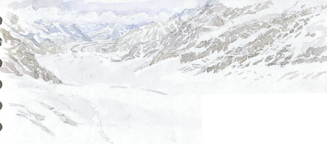
The Aletsch Glacier
At 23 kilometres (17 miles) long, the Aletsch Glacier is the longest – and also the widest – in Europe. There are no trees or buildings to give an idea of scale in this mountain landscape. It’s not until later, when I see figures far below walking on the glacier and tobogganing in the Snow Fun area, that I realise that those crevases on the left would be large enough to swallow up our house.
Ascending from Wengen (1274 m, 4180 ft) to Jungfraujoch (3454 m, 11333 ft) involves a large drop in air pressure so when I attempt to start drawing with my ArtPen, a fountain pen, I find that the ink leeks out uncontrollably. Luckily this doesn’t affect my Pilot Drawing Pens which are fibre tips.
For the view of the Aletsch Glacier I switch to pencil for the drawing before adding watercolour. In the original of this drawing the watercolour washes fade imperceptably into the white of the paper, something that seems to be impossible to reproduce in a low res scan.
As I sit on the floor by a full-length window in the coffee shop I’m just on level with a small Japanese boy who ask me repeatedly (as his father eventually translates) why don’t I use brighter colours, such as red.
Two South Korean women ask if they can photograph my drawing then photograph me with my sketchbook. I’m touched by the way they thank me; standing, side by side and bowing in unison.
Jungfrau from the Sphinx (left), which is the highest point you can visit at Jungfraujoch .
Pressure change also affects the journey down; I drink the last of my water as we wait for the train to set off, then screw the cap back onto the bottle. When I take the bottle out of my bag in the hotel, I discover that it has collapsed under the increased pressure.
WE WERE heading elsewhere but the view of the Lauterbrunnen valley – the valley of 72 waterfalls – as we descend on the funicular railway proves irresistible. After so much travelling yesterday, we’re ready to leave the station behind us and stroll in the sun towards the head of the valley.
It’s an easy walk, mainly along quiet lanes, from Lauterbrunnen to Stechelberg and the Trummelbach Falls make a spectacular break along the way. Not that there’s much to see of the Falls from the Trummelbach hotel where I made the drawing above, looking towards the top of the valley. A glacier-fed torrent from the Jungfrau and its surroundings has tunnelled its way down through the limestone, so you need to ascend by lift and hundreds of steps into the cliff to see – and hear – the spectacle.
I’d forgotten my watercolours, so my drawings today, including this one (above) from a shady bench across the valley from Trummelback, are in pen and ink. The jagged line at the bottom is the channel the Falls take, fed by the hanging valley as a gutter feeds a drain-pipe. Above the cliff-top line of trees in the distance there’s an ice-fall, or perhaps I should describe it as a small glacier. The summit of the Jungfrau is lost in cloud.
Mürren
We take a lunch stop at a kiosk cafe near the Stechelberg cable car station at the top of valley, sharing a local dish; Chäschüechi, a kind of mildly cheesy quiche with a pastry base and a light egg and cheese topping, seasoned with nutmeg.
We take the cable-car up to Mürren then the railway back to Grütschalp to descend via another cable-car to Lauterbrunnen. There’s a steady flow of people leaping from the tops of these cliffs and either making their way down gradually via parachute or, alarmingly, leaving it until the last possible moment to pull the chord, giving them just enough time to slow down before they reach the fields below.
Red deer antlers in the dining room at the Bernerhof Hotel.
THE REAR WINDOW of our apartment on Glassford Street, Glasgow, where we stayed last weekend, looked out over a yard. The wall of the adjoining building was constructed of rough-hewn stone and I noticed these fossil ripple-marks in two of the blocks.
The nearest that I’ve seen to this type of rock is the light grey Carboniferous limestone of the Yorkshire Dales, although you can see that one of the blocks (lower right) has a warmer, sandy colour.
Quarries in Bishopriggs, 3 or 4 miles to the north, supplied a pale golden brown sandstone from the Carboniferous limestone formation (locally classified as the Clackmannan Group) which was used in the construction of Victorian Glasgow, so perhaps these ripples formed in a tropical lagoon 320 million years ago, when Glasgow lay close to the equator.
This photograph looks rather like a scree-slope on a Lakeland fell but in fact each of these slate-like fragments is less than a millimetre across, smaller than the commas on this page. It’s a piece of roofing felt taken at 60x magnification through my microscope. The felt is bitumen-coated with a ‘green mineral’ finish, but it looks browner in my photograph. The flaky shapes and the colour make me guess that this is a green variety of Muscovite mica called fuchsite. The flakes (laminæ) of Muscovite are thin and surprisingly flexible, so they’re ideal as a coating on rolls of roofing felt.
There’s another mineral present; the rounded, glassy mineral near the bottom left-hand corner is a worn grain of sand, silica.
Fuchsite is rich in chromium but like other micas, as a form of silicate, it has a chemical composition based on aluminium, silica and oxygen (AlSi3O10). Micas are part of the group of minerals known as Phyllosilicates or sheet silicates, which take their name from phyllon, the Greek for leaf.
It was sparrows pecking on our newly felted shed roof that prompted me to take a closer look at its composition. Why should sparrows feel the need to peck at flakes of mica?
Muscovite is 2-4 on the Mohs scale of hardness, depending whether you’re testing the softer ‘sides’ or the harder face of the flakes. This means that it’s somewhere between a finger-nail and a pocket-knife in hardness, so the sparrows might swallow it as a form of ‘gritting’. The flakes might be used in the bird’s gizzard to help grind down the seeds and grain that form its staple diet. Fuchsite is made of clayey minerals so it might also have medicinal properties that help with digestion, just as we’d take kaolin, a fine white clay that is another form of sheet sillicate.
Sparrows will also peck at mortar on walls (right), which gives them access to more minerals; silica in the sand and the calcium carbonate in the cement.
When Paul and I put the new roofing felt I predicted that the sparrows would love it: “It’s like putting a new sheet of Tydsan in a budgie’s cage!”
Tydsan is the trade name of sheets of sandpaper, cut to size.
“Our budgies had to make do with newspaper in their cages!” Paul tells me.
 THIS MUCH-INITIALLED gritstone boulder sits on top of the Cow at the Cow and Calf Rocks above Ilkley. To get this view I had to perch on another boulder, which wasn’t comfortable enough to encourage me to sit and draw it there and then so I took a photograph and today I’ve been working from that.


 WE WERE heading elsewhere but the view of the Lauterbrunnen valley – the valley of 72 waterfalls – as we descend on the funicular railway proves irresistible. After so much travelling yesterday, we’re ready to leave the station behind us and stroll in the sun towards the head of the valley.


 THE REAR WINDOW of our apartment on Glassford Street, Glasgow, where we stayed last weekend, looked out over a yard. The wall of the adjoining building was constructed of rough-hewn stone and I noticed these fossil ripple-marks in two of the blocks.
 Dales, although you can see that one of the blocks (lower right) has a warmer, sandy colour.

